£19.14
Add to Cart
VUS030R Bluechart Vision HD G2 Southeast Caribbean Map - for listed compatibles
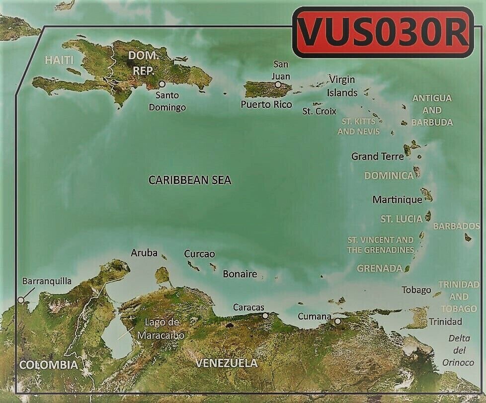


Bluechart G2 Vision HD Southeast Caribbean Chart - VUS030R Package includes: pre-loaded MicroSD map card, and an optional full size SD adapter is available upon request. Works in GPS models listed in the compatible device list. You may use HomePort on your computer with this digital map to plan your routes/trips. At checkout, leave us a message/note indicating your GPS model. Domestic shipping is via USPS first class with tracking, expedited shipping is available. Bluechart G2 Vision HD cards enhance a compatible Garmin Chartplotter with the following detail: Up to 1-foot HD contours provide a more accurate depiction of bottom structure for improved fishing charts and navigation in swamps, canals, marinas and port plansHigh-resolution satellite imagery when overlaid on the chart, will provide the mariner with unparalleled situational awarenessAerial reference photography provides “real world” photos of ports, harbors, marinas, waterways, navigation landmarks and other points of interest, offering the mariner another powerful tool for navigating unfamiliar watersMariners Eye view – Provides the mariner with a 3-D perspective of chart information for a quick, reliable and easy position fixFish Eye view – 3D perspective below the water line for displaying bottom contours based on bathymetric charting dataAuto guidance technology will search the attributes of all relevant charts to suggest the best course for navigationFishing charts, tides, currents, marine services, coastal roads and points of interest detailPatented Garmin Auto Guidance 3.0 technology is now capable of providing routing guidance¹ to virtually any accessible destination on the water. Coverage: Covers the Caribbean from Haiti to Trinidad & Tobago including Puerto Rico and all of the Lesser Antilles. Also includes the Colombian and Venezuelan coasts from Barranquilla, Colombia to the mouth of the Orinoco River, including Lake Maracaibo and the Gulf of Paria.Compatible Devices: echoMAP™ 43dv / 44dv / 50dv / 50s / 53dv / 54dv / 70dv / 70s / 73dv / 73sv / 74dv / 74sv / 93sv / 94sv echoMAP™ CHIRP 42cv / 42dv / 43cv / 43dv / 44cv / 44dv / 45cv / 45dv / 52cv / 52dv / 53cv / 53dv / 54cv / 54dv / 55cv / 55dv / 72cv / 72dv / 72sv / 73cv / 73dv / 73sv / 74cv / / 74sv / 75cv / 75dv / 75sv / 92sv / 93sv / 94sv / 95sv Not compatible in echoMAP Plus and UHDx models GPSMAP / 276 Cx / 4008 / 4010 / 4012 / 420/420s / 4208 / 421 / 4210 / 4212 / 421s / 430/430s / 431 / 431s / 440/440s / 441 / 441s / 5008 / 5012 / 5015 / 520/520s / 5208 / 521 / 521s / 5212 / 5215 / 525/525s / 526/526s / 1020xs / 1040xs GPSMAP 527xs / 530/530s / 531 / 531s / 535/535s / 536 / 536s / 540/540s / 541 / 541s / 545/545s / 546 / 546s / 547 / 547xs / 6208 / 6212 / 62s / 62st / 640 / 64 / 64csx / 64s / 64sc / 64st / 64sx / 64x / 65 / 65s / 720 / 720s / 722 / 722xs / 7212 / 7215 / 722 / / 7407 / 7407xsv / / 7408 / / 741xs / 7410 / 7410xsv / 7412 / 7416 / 741xs / 7607 / 7608 / 7610 / 7612 / 7616 / 78 / 78s / 78sc / 840xs / 86i / 86s / 86sc Monterra®Oregon® 700 / 750 / 750t Rino® 750 / 755t Volvo Penta Glass Cockpit System (GPSMAP 8000V) If you have questions, please let us know by email message on eCRATER. Buy with confidence from an eCRATER verified seller - you are protected!SATISFACTION GUARANTEED OR YOUR MONEY BACK!If you are not satisfied with your purchase for any reason you may return it to us within 30 days for full refund. SHIPPING: The sale includes a pre-loaded microSD card. If you need an SD adapter, please notify us to include one by the “Message to seller” button at the check-out screen. We ship out in the next business day after receive payment.The default shipping option is a 4-day standard shipping to any US territories. OpenStreetMap® is open data, licensed under the Open Data Commons Open Database License (ODbL) by the OpenStreetMap Foundation (OSMF) "Garmin" is a registered trademark Garmin Ltd Photos are for reference only

