£19.89
Add to Cart
BlueChart G2 Vision HD Chart VUS513L covering Jacksonville-Bahamas area
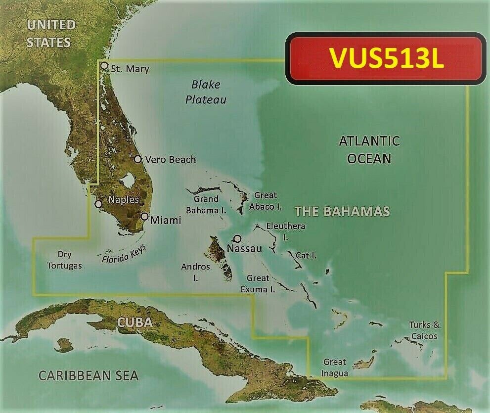


Bluechart G2 Vision HD Jacksonville - Bahamas Chart - VUS513L Bluechart G2 Vision HD Jacksonville - Bahamas Chart - VUS513L Package includes: Pre-loaded MicroSD map card An optional full size SD adapter is available upon request Features: Up to 1-foot HD contours for improved fishing charts and navigation High-resolution satellite imagery for unparalleled situational awareness Aerial reference photography for "real world" photos of ports, harbors, and more Mariners Eye view and Fish Eye view for 3-D perspective and bottom contour display Auto guidance technology for suggested navigation routes Fishing charts, tides, currents, marine services, and points of interest detail Patented Garmin Auto Guidance technology for routing guidance to virtually any destination on the water Coverage: Detailed coverage of the Florida Peninsula from St. Mary's, GA through the Port of Miami to Fort Myers on the Gulf. Coverage includes the St. Johns River, Crescent Lake, Lake George, Lake Monroe, Lake Jesup, Lake Harney, Lake Okeechobee, the St. Lucie Canal, and Caloosahatchee R. in full. Detailed coverage also includes the Florida Keys, Bahamas and Turks and Caicos Islands. Bathymetric coverage of offshore features from Blake Canyon through Santaren Channel to the Torgtugas Terrace, including the Blake Escarpment and Great Bahama Bank. Compatible Devices: EchoMAP™: 43dv, 44dv, 50dv, 50s, 53dv, 54dv, 70dv, 70s, 73dv, 73sv, 74dv, 74sv, 93sv, 94sv EchoMAP™ CHIRP: 42cv, 42dv, 43cv, 43dv, 44cv, 44dv, 45cv, 45dv, 52cv, 52dv, 53cv, 53dv, 54cv, 54dv, 55cv, 55dv, 72cv, 72dv, 72sv, 73cv, 73dv, 73sv, 74cv, 74dv, 74sv, 75cv, 75dv, 75sv, 92sv, 93sv, 94sv, 95sv Not compatible in EchoMAP Plus and UHD models. Shipping: Domestic shipping is via USPS first class with tracking, expedited shipping is available. Note: At checkout, please leave us a message indicating your GPS model. If you have questions, please let us know. OpenStreetMap® is open data, licensed under the Open Data Commons Open Database License (ODbL) by the OpenStreetMap Foundation (OSMF). "Garmin" is a registered trademark of Garmin Ltd. Photos are for reference only.

