£58.98
Add to Cart
Garmin BlueChart g3 Vision HD - VEU012R - Italy, West Coast - microSD/SD
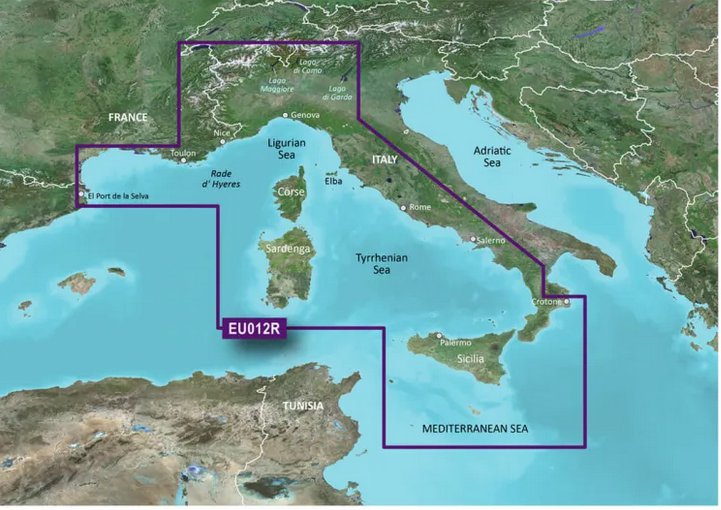


VEU012R BlueChart G2 Vision MARINE GPS MAP micro SD/SD FOR GARMIN GPS/SOUNDER Please make sure your device has a card slot that accepts either SD or micro SD format before purchasing. Package includes: 1 Micro SD card with map . Works in Garmin handheld GPS units or chartplotters that accept a micro SD card or full size SD card. You may use HomePort on your computer with this digital map to plan your routes/trips. At checkout, leave us a message indicating your GPS model. Will include with Full size SD adapter upon request This version is not locked so it can be used in multiple units that are compatible, it only works in a compatible GPS. Features Includes realistic navigation features showing everything from shaded depth contours and coastlines to spot soundings, navaids, port plans, wrecks, obstructions, intertidal zones, restricted areas, IALA symbols and more.Features smooth displays, including seamless transitions between zoom levels and more continuity across chart boundaries.Allows users to choose between standard 2-D direct overhead or 3-D ""over the bow"" map perspective to make chart reading and orientation easier.Provides Safety Shading (in compatible units), allowing mariners to enable contour shading for all depth contours shallower than user-defined safe depths.Provides Fishing Charts (in compatible units), allowing mariners to scope out bottom contours and depth soundings with less visual clutter on the display. Coverage Detailed coverage of the Mediterranean coast from Llafranc, ES to Crotone, IT including the coasts of France, Monaco, and the west coast of Italy. Also includes detailed coverage of Lac de Geneve, Lago Maggiore, Lago di Lugano, Lago d'Iseo, Lago di Como and Lago di Garda in northern Italy. Island coverage features Corse, Sardegna, Sicilia, and Malta. Compatible Devices: Alpha® 100 Astro® 320 / 430 Dakota® 20 eTrex® 20 / 30 / Touch 25 / Touch 35 / Touch 35t echoMAP™ 43dv / 44dv / 50dv / 50s / 53cv / 53dv / 54dv / 70dv / 70s / 73dv / 73sv / 74sv / 93sv / 94sv echoMAP™ CHIRP 42cv / 42dv / 43cv / 43dv / 44cv / 44dv / 45cv / 45dv / 52cv / 52dv / 53cv / 53dv / 54cv / 54dv / 55cv / 55dv / 72cv / 72dv / 72sv / 73cv / 73dv / 73sv / 74cv / 74dv / 74sv / 75cv / 75dv / 75sv / 92sv / 93sv / 94sv / 95sv NOT for the echoMAP Plus and echomap UHD series! GPSMAP 276Cx / 4008 / 4010 / 4012 / 4208 / 420/420s / 421 / 4210 / 4212 / 431 / 431s / 441 / 441s / 5008 / 5012 / 5015 / 5208 / 521 / 5212 / 5215 / 520/520s / 521s / 526 / 526s / 531 / 531s / 536 / 536s / 541 / 541s / 545/545s / 546 / 546s / 62 / 6208 / 6212 / 62s / 62sc / 62st / 62stc / 64s / 64st / 640 / 66s / 720 / 720s / 721xs / 7212 / 7215 / 740 / 7407 / 7407xsv / 7408 / 7408xsv / 740s / 741 / 741xs / 7410 / 7412 / 7416 / 7607 / 7607xsv / 7608 / 7610 / 7612 / 7616 / 78 / 78s / 78sc / 840xs / 86i / 86s / 86sc / 1020xs / 1040xs Colorado® 300 / 400c / 400i / 400t Montana® 600 / 600t / 610 / 610t / 650 / 650t / 680 / 680t Monterra Oregon® 450 / 450t / 550 / 550t / 600 / 600t / 650 / 650t/750/750t Rino® 750 / 755t We will promptly answer any questions you might have. Tracked delivery by USPS First Class OpenStreetMap® is open data, licensed under the Open Data Commons Open Database License (ODbL) by the OpenStreetMap Foundation (OSMF) ""Garmin"" is a registered trademark Garmin Ltd This product is not affiliated with Garmin. Photos are for reference only " BlueChart VEU012R G2 Vision MARINE GPS MAP GARMIN GPS (Digital Delivery) "BlueChart G2 Vision GPS MAP GARMIN GPS/SOUNDER (Digital Delivery) Within 24 hours after placing your order you will receive a download link with simple instructions. You will need a blank 4gb 32GB SD card. Please make sure your device has a card slot that accepts either SD or micro SD format before purchasing. This version is not locked so it can be used in multiple units that are compatible, it only works in a compatible GPS. Features Includes realistic navigation features showing everything from shaded depth contours and coastlines to spot soundings, navaids, port plans, wrecks, obstructions, intertidal zones, restricted areas, IALA symbols and more.Features smooth displays, including seamless transitions between zoom levels and more continuity across chart boundaries.Allows users to choose between standard 2-D direct overhead or 3-D ""over the bow"" map perspective to make chart reading and orientation easier.Provides Safety Shading (in compatible units), allowing mariners to enable contour shading for all depth contours shallower than user-defined safe depths.Provides Fishing Charts (in compatible units), allowing mariners to scope out bottom contours and depth soundings with less visual clutter on the display. Coverage Detailed coverage of the Mediterranean coast from Llafranc, ES to Crotone, IT including the coasts of France, Monaco, and the west coast of Italy. Also includes detailed coverage of Lac de Geneve, Lago Maggiore, Lago di Lugano, Lago d'Iseo, Lago di Como and Lago di Garda in northern Italy. Island coverage features Corse, Sardegna, Sicilia, and Malta. Compatible Devices: Alpha® 100 Astro® 320 / 430 Dakota® 20 eTrex® 20 / 30 / Touch 25 / Touch 35 / Touch 35t echoMAP™ 43dv / 44dv / 50dv / 50s / 53cv / 53dv / 54dv / 70dv / 70s / 73dv / 73sv / 74sv / 93sv / 94sv echoMAP™ CHIRP 42cv / 42dv / 43cv / 43dv / 44cv / 44dv / 45cv / 45dv / 52cv / 52dv / 53cv / 53dv / 54cv / 54dv / 55cv / 55dv / 72cv / 72dv / 72sv / 73cv / 73dv / 73sv / 74cv / 74dv / 74sv / 75cv / 75dv / 75sv / 92sv / 93sv / 94sv / 95sv NOT for the echoMAP Plus and echomap UHD series! GPSMAP 276Cx / 4008 / 4010 / 4012 / 4208 / 420/420s / 421 / 4210 / 4212 / 431 / 431s / 441 / 441s / 5008 / 5012 / 5015 / 5208 / 521 / 5212 / 5215 / 520/520s / 521s / 526 / 526s / 531 / 531s / 536 / 536s / 541 / 541s / 545/545s / 546 / 546s / 62 / 6208 / 6212 / 62s / 62sc / 62st / 62stc / 64s / 64st / 640 / 66s / 720 / 720s / 721xs / 7212 / 7215 / 740 / 7407 / 7407xsv / 7408 / 7408xsv / 740s / 741 / 741xs / 7410 / 7412 / 7416 / 7607 / 7607xsv / 7608 / 7610 / 7612 / 7616 / 78 / 78s / 78sc / 840xs / 86i / 86s / 86sc / 1020xs / 1040xs Colorado® 300 / 400c / 400i / 400t Montana® 600 / 600t / 610 / 610t / 650 / 650t / 680 / 680t Monterra Oregon® 450 / 450t / 550 / 550t / 600 / 600t / 650 / 650t/750/750t Rino® 750 / 755t We will promptly answer any questions you might have. Tracked delivery by USPS First Class OpenStreetMap® is open data, licensed under the Open Data Commons Open Database License (ODbL) by the OpenStreetMap Foundation (OSMF) ""Garmin"" is a registered trademark Garmin Ltd This product is not affiliated with Garmin. Photos are for reference only "

